What is GPR? A Simple Introduction to Subsurface Imaging
Ever wondered how you can see inside solid concrete or find what's buried underground without digging a single hole? Our new guide to ground penetrating radar explains it all. We dive into how this powerful subsurface imaging technology works, why it's a project-saver in construction, and how it differs from a concrete X-ray. Before your next project, learn how this non-destructive testing method is used for everything from utility locating to finding rebar, preventing costly and dangerous mistakes.
Before you drill into a concrete wall or excavate for a new foundation, one question looms: what’s hidden just beneath the surface? Hitting a buried utility, a post-tension cable, or critical rebar can lead to costly delays and dangerous accidents. This is precisely why understanding what is GPR is so critical for any modern project. Ground penetrating radar, or GPR, is a powerful form of subsurface mapping that allows you to "see" underground without ever breaking ground, providing a clear picture of what lies beneath.
But how does GPR work? Is it the same as a concrete X-ray? In this simple introduction, we will explore the science behind this essential geophysical survey method, from its use of electromagnetic pulses to the complex radargrams it produces. You will learn what GPR is used for in the real world, whether it's for concrete scanning, void detection, locating non-metallic pipes, or even archaeological investigations. By the end of this post, you'll understand how this non-destructive testing technology provides the critical insights needed to plan your project safely and efficiently.
What is GPR?
We have all been there. You are about to hang a heavy mirror or a new TV, you pick the perfect spot, and just as you are about to drill, a wave of panic hits you. What if I hit a pipe? What if I drill right into an electrical wire? Now, imagine that feeling on a massive scale, where you are a construction manager about to cut a five-foot opening in a concrete floor, and a mistake could mean cutting a critical utility line or, worse, a structural cable. This is where understanding what is GPR becomes so valuable.
A Simple Analogy: What is GPR in Everyday Terms?
At its simplest, ground penetrating radar is a lot like a high-tech fish-finder or a medical ultrasound. It is a device that lets you see what is going on beneath the surface without physically disturbing it. A fish-finder sends a pulse of sonar (sound) down into the water, and when that pulse hits a fish or the lakebed, an echo bounces back. The device measures how long that echo took to return and draws a picture of what is below.
GPR does the exact same thing, but for the ground. It sends a tiny, safe pulse of electromagnetic energy (a radar wave) into a structure, like concrete or soil, and it "listens" for the echoes that bounce back from hidden objects. You could think of it as a super-powered stud finder, but instead of just detecting wood, it can find pipes, rebar, wires, and even changes in the soil itself.
The Technical Answer to "What is GPR?"
If we want to get a bit more technical, the answer to "what is GPR" is that it is a geophysical method of subsurface imaging. That sounds complicated, but it just means it is a scientific way to map the subsurface. It is a primary tool used in non-destructive testing, or NDT, which is an entire industry built around inspecting materials and structures without damaging them. GPR technology gives us the ability to perform a non-invasive inspection, gathering data and creating a map of hidden features so that project managers can make informed decisions.
What is GPR vs. Other Technologies (Like X-Ray)?
You might be wondering if this is the same as a concrete X-ray. It is a common question, and while they are both imaging tools, they are very different. I was on a project once where the client kept asking for an X-ray of a thick concrete wall, but it was not practical. An X-ray, just like a medical one, requires a transmitter on one side and a receiver (or film) on the other. This is often impossible on a concrete slab or a foundation wall. X-ray technology also uses ionizing radiation, which requires an exclusion zone for safety.
What is GPR's advantage? It is much more flexible. GPR is single-sided, meaning the same unit both sends and receives the signal, so you only need access to one surface. It is also completely safe, using the same type of non-ionizing radiation found in microwave ovens and radio waves, but at a much lower power level.
It also differs from a standard utility locator. Those tools, often called electromagnetic (EM) locators, are great at finding metallic pipes and electrical cables because they detect the electromagnetic field radiating from them. But what if the pipe is plastic, or you are looking for a void? An EM locator will miss it completely. GPR, on the other hand, can find both metallic and non-metallic objects, making it incredibly versatile.
The Science Behind the Scan: How Does GPR Technology Work?
So, how does this high-tech "stud finder" actually see into the ground? The magic is in the physics, but the process is surprisingly straightforward.
The Main Components: What is a GPR System?
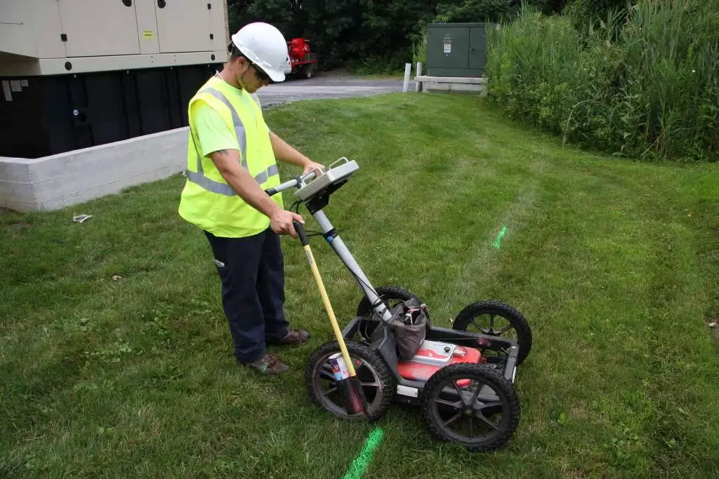
A typical GPR system, especially one used for concrete scanning, often looks like a high-tech lawnmower or cart. It consists of three main parts. First is the control unit, which is the "brain" of the operation, often a rugged tablet or computer that processes the data. Second is the antenna, the boxy part at the bottom that rolls along the ground. This is the most important piece, as it houses both the transmitter that sends the radar pulse and the receiver that catches the echo. Finally, you have the display, where the technician sees the data in real-time.
The Process: From Pulse to Picture
When we push the GPR system across a surface, the antenna is constantly sending out tiny electromagnetic pulses, hundreds of times per second. These waves travel through the material. As long as the material is uniform, the wave keeps going. But the moment that wave hits something with different electrical properties, a change known as the dielectric constant, a portion of that energy is reflected.
This "something" could be a metal pipe, a PVC conduit, a change in soil density, or even an air pocket (a void). The antenna’s receiver catches this reflected wave, and the control unit measures the exact time, in nanoseconds, it took for the pulse to travel from the antenna, hit the object, and bounce back. Because the wave travels at a known speed through that material, the system can instantly calculate the object's depth with remarkable accuracy.
Reading the Results: What is a GPR Radargram?
This is the part that takes the most skill, and it is where a good technician earns their keep. The GPR display does not show a photograph or a 3D model of a pipe. It shows a continuous, two-dimensional graph called a radargram. As the unit moves, it creates a cross-section view of the ground.
When the GPR passes over a small, round object like a pipe or a piece of rebar, the reflections form a very distinct shape on the radargram: a "hyperbola," which looks like an upside-down 'U'. I always tell our new trainees that learning to read these hyperbolic reflections is the most important part of the job. An experienced technician can look at the shape, brightness, and polarity of that hyperbola and perform the data interpretation, telling you not just that something is there, but likely what it is. A bright, sharp hyperbola might be a metal conduit, while a less-defined one could be a PVC pipe.
Real-World Applications: What is GPR Used For?
This technology is fantastic, but what is GPR actually used for in the field? This is where it gets really interesting. GPR has become an indispensable tool in dozens of industries.
What is GPR in Construction and Concrete Scanning?
This is probably the most common application you will see. In construction and renovation, GPR is the gold standard for concrete scanning. Before a crew drills a hole to run new plumbing or cuts a trench for an electrical line, they call us. We perform a scan to map out exactly what is inside the concrete.
Our GPR equipment helps us with rebar locating, showing the precise grid of reinforcement. We can find electrical conduits and prevent a crew from drilling into a live wire. Most critically, we locate post-tension cables. I was on a high-rise renovation project once where the engineer was terrified of cutting a post-tension cable, which is under thousands of pounds of pressure and can cause a catastrophic failure if cut. Our GPR scan mapped every single cable, giving the crew a clear, safe path to do their work. We also use it for void detection to find air gaps under a slab that could indicate a sinkhole or a washout before the floor collapses.
What is GPR for Subsurface Utility Engineering (SUE)?
Subsurface Utility Engineering, or SUE, is the professional practice of mapping underground utilities. When you "call 811 before you dig," that service typically only marks public utilities up to your property line. But what about all the private gas lines, water pipes, and electrical wires running from there to the building?
That is where we come in. GPR is a key tool in SUE for utility locating. Because it can find both metallic and non-metallic utilities, we can locate those elusive PVC water lines or fiber optic cables that traditional locators miss. We also get many calls for locating underground storage tanks (USTs) on old gas station properties or industrial sites, which is a critical part of any environmental assessment.
What is GPR in Environmental and Geological Surveys?
Geologists and environmental scientists use GPR to look much deeper. With different, lower-frequency antennas, we can perform a geophysical survey to map soil stratigraphy, which means we can see the different layers of soil, clay, and rock. This can be used to find the depth of bedrock, map the groundwater table, or even investigate the boundaries of old landfills.
What is GPR in Archaeology and Forensics?
This is the application that often gets people excited. GPR is a powerful, non-invasive tool for archaeologists. Instead of digging and potentially-destroying a sensitive site, they can use GPR to find buried foundations of ancient buildings, lost walls, or other artifacts. It is also used in forensics and for cemetery mapping, where it can be used to help locate unmarked graves with dignity and respect, preserving historical sites or assisting in investigations.
The Advantages: Why Understanding "GPR" is a Project-Saver
When you understand what GPR is, you start to see it less as a cost and more as a crucial investment that saves time, money, and most importantly, lives.
Safety First: What is GPR's Role in Damage Prevention?
The number one benefit of GPR is damage prevention. The entire point of this non-destructive and non-invasive inspection is to find problems before they happen. Hitting a live electrical conduit can injure a worker. Cutting a post-tension cable can compromise a building’s integrity. Severing a fiber optic line can take out a business’s entire communication network, costing them thousands per minute. GPR scanning is a simple, proactive step to prevent all of it.
Speed and Efficiency: How GPR Provides Real-Time Answers
GPR is incredibly fast. An experienced technician can scan thousands of square feet of concrete in a single day. Because the data is collected in real-time, we can often give answers right on the spot. I can scan a section of a slab and immediately mark out a clear zone for a plumber to drill, allowing the project to keep moving without delay.
What is GPR's Unique Advantage? Finding the "Unfindable"
I will say it again because it is so important: GPR’s greatest strength is its ability to find the "unfindable." It is often the only practical technology that can locate non-metallic utilities, plastic pipes, air-filled voids, and embedded fiber optics. While other tools have their place, GPR provides the most comprehensive picture of the subsurface.
What is GPR Not? Key Limitations to Understand
As much as I love this technology, I believe in being honest with our clients. GPR is a powerful tool, but it is not magic, and it has limitations. Understanding what GPR is also means understanding what it is not.
The Depth vs. Resolution Trade-Off
There is a fundamental trade-off in GPR: depth versus resolution. This is all controlled by the GPR antenna frequencies. A high-frequency antenna, say 2600 MHz, sends out short, choppy waves that give us a beautiful, high-resolution picture. It is perfect for concrete scanning, allowing us to see individual pieces of rebar that are close together. The catch? That signal weakens very fast. It may only see 12 to 18 inches deep.
A low-frequency antenna, like a 250 MHz, sends out a long, powerful wave that can penetrate 10, 15, or even 20+ feet deep, making it ideal for utility locating. The trade-off is that the image is much "blurrier," and it will not be able to distinguish two small targets that are close together. Part of our job is to choose the right antenna for the application.
When GPR Struggles: The Impact of Soil Conditions
GPR has one major enemy: highly conductive materials. The radar signal, being electromagnetic, is quickly absorbed or "attenuated" by anything that conducts electricity well. The worst offender? Wet, salty, or dense clay.
I have been on job sites where the ground is full of heavy, wet clay, and the GPR signal attenuation is so bad that we can barely see a foot deep. It is like trying to shine a flashlight through mud. On the other hand, GPR works beautifully in dry, sandy soils or materials like limestone and, of course, concrete. A good provider will always ask about the soil conditions before promising results.
What is GPR Data? (It's Not a Photograph)
This is the most important limitation to remember. The GPR data is not a photograph. It is a collection of lines, waves, and hyperbolic reflections on a radargram. The value of a GPR survey is not in the equipment itself, but in the skill and experience of the technician performing the data interpretation. An inexperienced operator can easily misinterpret a cluster of rocks as a burial, or miss a conduit that is running at an angle. The tool is only as good as the expert running it.
What GPR Means for Your Next Project
Understanding what is GPR is no longer a complex mystery. You now have a clear picture of how this powerful subsurface imaging technology is a game changer for countless projects. You have learned that GPR is a safe, non-invasive, and remarkably efficient way to see inside concrete and underground. You know that its strength lies in its ability to locate both metallic and non-metallic targets, from rebar and conduits to PVC pipes and voids, all by interpreting the echoes of electromagnetic pulses.
This knowledge is more than just technical, it is your first line of defense against the unknown. By understanding what GPR is, you understand how to prevent costly and dangerous utility strikes, avoid cutting critical structural components, and gather the essential data needed to plan your work with confidence. The true value of a GPR scan is the power of certainty it provides.
Don't leave the safety and success of your next project to guesswork. If you are ready to move from wondering what is beneath the surface to knowing exactly what is there, it is time to bring in an expert. Contact JLP Tech to get started today, and let our skilled technicians help you see what lies beneath.
Ready to Build with Confidence?
Don't let hidden pipes or rebar derail your project. With our expert utility locating and ground-penetrating radar services in Colorado, you can dig, drill, and build with certainty. We help you avoid costly surprises and dangerous accidents, ensuring your project stays on schedule and on budget. Whether you're a homeowner starting a backyard project or a construction manager overseeing a large build, we've got the technology and expertise to give you a clear view of what's underground.